Northern Ireland Statistics and Research Agency

Main navigation

  • Home
  • Statistics and Research
  • Release Calendar
  • Selected for a survey
  • About Us

Breadcrumb

  1. Home
  2. Statistics and Research
  3. Geography

Output Areas (Census 2001)

Output Areas (OAs) were introduced in Northern Ireland after the 2001 Census.

Overview

Output Areas (OAs) nest within the 582 Electoral Wards in Northern Ireland and were designed to have similar population sizes of around 125 households and 350 people, they are also as socially similar as possible. There are 5022 OAs in Northern Ireland.

Output Areas (OAs) do not nest within the new 11 Local Government Districts (LGD2014) but a best-fit lookup table has been created. Technical guidance document and look-up tables are available.

Geography preview
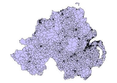
Output Areas

Attribute table

VariableDescription
X_Popcoord*Geographic coordinate easting for population-weighted centroid 
Y_Popcoord*Geographic coordinate northing for population-weighted centroid  
HectaresArea in hectares
X_CoordGeographic coordinate easting for geographically weighted centroid
Y_CoordGeographic coordinate northing for geographically weighted centroid
OA_CodeOutput Area coding convention

Output Area boundaries in GIS format

  • ESRI Shapefile format (22.7MB)
  • Mapinfo format (24.0MB)
     

Last updated: 03 March 2025

Related to Output Areas (Census 2001)

Publications

  • Output Area Boundaries in GIS format

    Published 01 January 2016
See all publications in this topic

Links

  • Official Statistics producer – Upholding Trust, Quality and Value
  • General Register Office - registration and certification of life events relating to births, deaths and marriages
  • nidirect.gov.uk – the official government website for Northern Ireland citizens
  • Website feedback

Follow NISRA

  • Facebook
  • X
  • YouTube

Footer

  • © Crown Copyright
  • Terms and conditions
  • Cookies
  • Privacy
  • Accessibility Statement